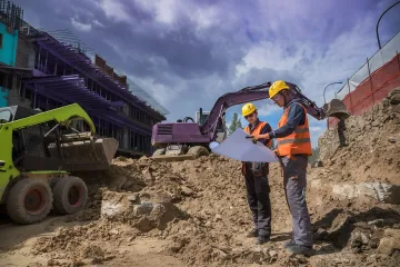
Site Surveying & Mapping
Precise topographic and boundary surveys using advanced GPS and LiDAR technology to establish accurate project baselines and spatial references for foundation planning.
Transform your foundation projects with precision geospatial engineering services that integrate advanced surveying, subsurface analysis, and spatial data solutions. Our comprehensive geospatial expertise ensures optimal foundation design, reduces construction risks, and delivers cost-effective solutions across diverse terrain and soil conditions for industrial, energy, and infrastructure applications.
Comprehensive spatial data solutions for precise foundation design, surveying, and construction optimization across all project types.
Precise topographic and boundary surveys using advanced GPS and LiDAR technology to establish accurate project baselines and spatial references for foundation planning.
Detailed geospatial mapping of soil conditions, bedrock depth, and underground utilities to optimize foundation design and identify potential construction challenges.
Advanced digital elevation models and contour mapping to visualize site conditions, calculate cut-fill volumes, and plan optimal foundation placement strategies.
Precise staking and positioning services using GPS technology to ensure accurate foundation placement according to engineering specifications and design requirements.
Comprehensive spatial documentation of completed foundation installations with accurate coordinates and elevation data for project records and future reference.
Advanced geographic information system solutions for project visualization, data management, and spatial analysis to support multi-phase foundation construction projects.
Our geospatial services integrate cutting-edge surveying technology with deep foundation engineering expertise to deliver precise spatial intelligence. From initial site assessment through final as-built documentation, we provide the critical spatial data that ensures optimal foundation performance, reduces construction risks, and accelerates project timelines across challenging terrain and complex soil conditions.
Delivering accurate geospatial solutions for foundation projects across diverse industries and challenging environments.
Our integrated approach combines advanced spatial technology with proven foundation expertise.
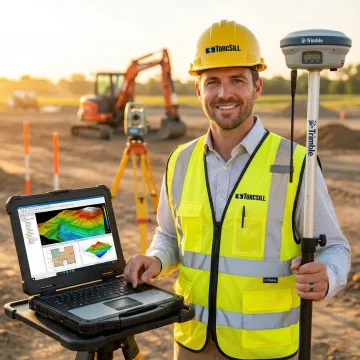
State-of-the-art GPS, LiDAR, and GIS systems for precise spatial data collection and analysis.
Deep understanding of foundation requirements ensures geospatial data directly supports optimal design solutions.
Licensed in 23 states with 14 service locations providing consistent geospatial services nationwide.
Seamless coordination between geospatial services, engineering design, and construction for streamlined project delivery.
Expert professionals driving spatial innovation in foundation design.
CEO
As CEO of TorcSill, Tim Swift leads the company's strategic vision in delivering innovative foundation solutions worldwide. With extensive experience in the foundation industry, he oversees the integration of advanced geospatial technologies with proven helical pile systems. Under his leadership, TorcSill has expanded to 14 operational locations and secured licensing in 23 states, establishing the company as the premier global provider of engineered foundation solutions. Tim's commitment to innovation drives TorcSill's continuous advancement in geospatial services, ensuring clients receive cutting-edge spatial intelligence for optimal foundation performance across diverse industries and challenging environments.

Director of Engineering
Raed El Cheikh serves as Director of Engineering at TorcSill, leading the technical innovation that drives the company's geospatial and foundation engineering excellence. With deep expertise in structural and geotechnical engineering, he oversees the development of integrated spatial solutions that optimize foundation design across complex projects. Raed's engineering leadership ensures seamless integration between geospatial data collection, analysis, and foundation system design, delivering enhanced project outcomes for clients in energy, industrial, and infrastructure sectors. His technical vision supports TorcSill's mission to provide the most advanced and efficient foundation solutions while maintaining the highest standards of engineering excellence and safety performance.
We provide comprehensive spatial data including topographic surveys, subsurface mapping, soil condition analysis, utility location, boundary surveys, and 3D terrain modeling using GPS, LiDAR, and GIS technology.
Connect with our spatial intelligence experts for comprehensive foundation surveying solutions.
Professional surveying and spatial analysis services delivered across multiple states and regions.
14 Offices
Service Locations
23+ States
Licensed States
Global Reach
Project Coverage
Contact us to discuss geospatial services for your foundation project location.

Quality management system certification
American Welding Society certified shop
Professional engineering licenses nationwide
Connect with our spatial intelligence experts to discuss your surveying and foundation design requirements.
For immediate assistance, feel free to give us a direct call at (800) 731-8672 You can also send us a quick email at [email protected]
For immediate assistance, feel free to give us a direct call at (800) 731-8672 You can also send us a quick email at [email protected]